
Aim High
The HIAPER Project for Environmental Research

The HIAPER Project for Environmental Research
The other day, I was reading an e-mail from the comfort of home on my wireless PDA. The topic was the appropriateness of a high-tech focus in an elective course for business majors. The authors did not think it was a great fit for business students as they would probably not work in high-tech fields. Thankfully, I was sitting down or I may have hit my head on the bathroom sink as I fainted.
The topic of “high-technology” is also being discussed by a school committee tasked with incorporating it into the classroom. One of our early impediments was defining high-tech in the first place. Too often, folks think it is using expensive gadgets for the sake of using expensive gadgets. High-technology professionals identify and use it for what it is — a tool that increases task convenience. If a high-tech solution makes your task more difficult, then it is not the correct solution. High-difficulty tasks are performed and made possible through the utilization of high-technology tools. The ability to communicate with my team through the air of my home is definitely a convenience, even though it does require the use of some modern gadgetry that was managed, marketed, and sold by business majors.
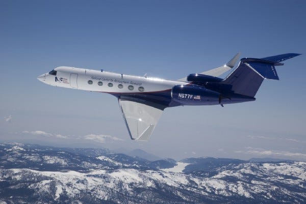
Thanks to the availability of high technology, the National Science Foundation’s National Center for Atmospheric Research (NSF/NCAR) can conceive of conducting experiments on the atmosphere at 50,000 feet while traveling Mach 0.8. This new flying convenience is disguised as a modified Gulfstream V (G5) aircraft known as the High-performance Instrumented Airborne Platform for Environmental Research (HIAPER). The structural modifications include the affixation of aperture pads and plates, fuselage mounts, upper and lower optical view ports, wing hard points, pylons, and pods, window blanks, and an external upper tail deck. All additions and modifications were made to accommodate a large number of proposed instruments while insuring the flight worthiness of the aircraft.
The basic G5 itself was delivered with a profusion of high-tech equipment necessary to insure safe operation. It is outfitted with a flight management system (FMS) that integrates displays, navigation, performance, guidance and flight sensor systems including dual cockpit monitors, avionics and guidance computers, three micro air data computer (MADC) sensors and triple inertial reference systems (IRS). Two global position sensors (GPS) communicate with the NAVSTAR GPS satellite constellation to determine precise three-dimensional aircraft position in coordination with two redundant distance measuring equipment (DME) systems that provide distance, time to station, ground speed, and station identification.
The dual, solid state air traffic control (ATC) systems reply to the automated interrogators of the Air Traffic Control Radar Beacon System (ATCRBS) for tracking, identification, and altitude reporting while the on-board Traffic Collision Avoidance System (TCAS) communicates with other transponder-equipped traffic in the vicinity that may present a collision hazard. The color Primus X-band digital weather radar system scans for adverse weather and turbulence while the Ground Proximity Warning System (GPWS) provides terrain-ahead awareness and windshear detection.
Once the HAIPER G5 pulls away from the gate, it must provide for the power, gas, and data needs of the experimental instruments as well as the comfort of the experimenters. The galley, lavatory, and gas cylinder storage areas are located at the rear of the plane. Integrated drive generators (IDGs) in each of the two Rolls-Royce turbofan jet engines provide regulated 60 Hz 115 VAC single-phase, 400 Hz 115/208 three phase, and 28 VDC power through secondary power distribution boxes (SPDB) located in the main cabin, the nose, the baggage compartment, and at each of the six wing hard points.
The G5 Aircraft Data System (ADS) provides distributed data sampling modules (DSM) through 16-bit ISA and 32-bit PCI PC-104 architecture. Analog signals are acquired at per-channel software selectable sample rates ranging from 10 Hz to 10 kHz at 14 to 16 effective bits of resolution. Digital inputs are provided in serial, parallel, and event counting formats using RS-232/422, ARINC-429, and HDLC protocols. Networking services are provided by an on board gigabit Ethernet over Cat-6 twisted pair wire and optical fiber cables. System time-of-day is acquired through the GPS and broadcast over the Ethernet in IRIG-B or network time protocol (NTP) in addition to a 1-PPS start-of-second signal for synchronization. Autonomous instruments may also be controlled from remote ground stations through a 128 K bit/sec satellite communication system.
The instruments under development for flight on the HAIPER G5 include small ice detector probes, radiation, and ozone measurement, trace organic gas analyzers, laser spectrometers, high-resolution lidar, mass spectrometers, temperature profilers, and cloud particle imagers. Even before it takes to the skies on its initial flight this June, the HAIPER G5 will be one of the highest-technology gadgets around.
This material originally appeared as a Contributed Editorial in Scientific Computing and Instrumentation 22:5 April 2005, pg. 12.
William L. Weaver is an Associate Professor in the Department of Integrated Science, Business, and Technology at La Salle University in Philadelphia, PA USA. He holds a B.S. Degree with Double Majors in Chemistry and Physics and earned his Ph.D. in Analytical Chemistry with expertise in Ultrafast LASER Spectroscopy. He teaches, writes, and speaks on the application of Systems Thinking to the development of New Products and Innovation.